|
 URBAN DESIGN STUDIES URBAN DESIGN STUDIES
Annual of the University of Greenwich Urban Design Unit
8 VOLUMES ISSN 1358-3255 Hardback
VOLUME 1 (1995) ISBN 987-1-870606-04-02 VOLUME 2 (1996) ISBN 978-1-870606-03-5 VOLUME 3 (1997) ISBN 978-1-870606-05-9 VOLUME 4 (1998) ISBN 978-1-870606-06-6 VOLUMES 5 & 6 (2000) ISBN 978-1-870606-07-3 VOLUME 7 (2001) ISBN 978-1-870606-08-0 VOLUME 8 (2002) ISBN 978-1-870606-09-7
PRICE: Volumes 1, 2, 3, 4, 7 and 8, £30.00 plus p&p, US$40.00 plus p&p Volumes 5 and 6 bound together, £50.00 plus p&p, US$67.00 plus p&p
ONLY FEW INDIVIUAL COPIES AND LESS THAN 10 SETS OF EIGHT VOLUMES ARE LEFT
The series Urban Design Studies explores all aspects of urban design, including the way it is taught, in articles by leading practitioners and academics. As our present urban forms have evolved as a result of their earlier history, our present views, ideologies, intentions, and even perceptions - whether false or real - effect our modern designs, and the cities of tomorrow. The debate on these issues is of prime concern, and Urban Design Studies was a pioneer in launching this multi-faceted subject as a discipline.
While what governs the shape of our cities and the environment of public or semi-public space is of course effected by the historical background of the place, by social traditions and by contemporary perceptions of urban dwellers towards their society, beneath it all there seem to be certain similarities in the form of urban environments word-wide which make them immediately identifiable to everyone. Studies on urban design will, therefore, remain part of a wide-ranging inter-disciplinary debate, without geographical boundaries or historical limitations. Urban design history too, cannot be merely a theoretical investigation of former designs or events, but is more likely to be an investigation into the existing form of a city and its effect on the life of its inhabitants. The series is essential reading for those involved in research and debate on all issues which have a bearing on the design of our urban environments. For contributors and articles in the individual volumes please see the list below.
 VOLUME 1 (1995) VOLUME 1 (1995)
CONTENTS:
Jon Rowland (Urban Design Group, Oxford): From the front line
Ian Bentley (Oxford Brookes University): What kind of art is urban design?
Anthony J. (Tony) Costello (Ball State University): MUDS: a focus for urban design education in `Middletown, USA
Renato Bocchi (Istituto Universitario di Architettura di Venezia): The contemporary view of the urban context in Italian architecture
Ali Madani-Pour (University of Newcastle upon Tyne): Dimensions of urban public space: the case of the Metro Centre, Gateshead
 Eamonn Canniffe (University of Manchester): Mannerist interventions: three sixteenth century Italian squares Eamonn Canniffe (University of Manchester): Mannerist interventions: three sixteenth century Italian squares
Tom Turner (The University of Greenwich): GIS and the rebirth of "planning"
Alistair Barr (The University of Greenwich): Preserved urban patterns: Hydra, Greece;
Duane Mezga (Michigan State University, East Leasing): Warsaw's Holocaust landscape
Philip Stringer and Martin Eyre (The University of Greenwich): The Ingolstadt Project: combating the defensive configuration: Urban design at the University of Greenwich 1994-95
Mehrdad Shokoohy (The University of Greenwich): Kirtipur: Ingolstadt Project cultural traditions under siege
 VOLUME 2 (1996) VOLUME 2 (1996)
Greg Castillo (University of California, Berkeley): Constructivism and the Stalinist Company Town;
Kiran Lalloo (University of Southern California): Healing through housing in South Africa: hope or despair?;
Peter Hall (The Bartlett, University College, London): Ealing, the Queen of London's Victorian railway suburbs
Valerie Alford (The University of Greenwich): Crime and space in the inner
City
Tarek Shalaby, Peter Ford and Keith Williams (University of Nottingham): Sustainable GIS technology for developing countries
 Catherine Teeling (The University of Greenwich): Algorithmic design: generating urban form Catherine Teeling (The University of Greenwich): Algorithmic design: generating urban form
Bob Jarvis (South Bank University, London): Mind/body: space/time: things/events
Ulrich Seitz (University of Stuttgart): The Stuttgart approach to urban design and town planning
Philip Stringer (The University of Greenwich): Axial investigations, a study of Nimes, France: Urban design at the University of Greenwich 1994-95
A study of Nimes, France
 VOLUME 3 (1997) VOLUME 3 (1997)
Hugh Campbell (University College, Dublin): Religion and the city: the Catholic Church in Dublin 1691-1878
Koen Steemers, Nick Baker, David Crowther, Jo Dubiel, Maria-Heleni Nikolopoulou and Carlo Ratti (University of Cambridge): City texture and microclimate
Uttam Sagar Shrestha (International Union for the Conservation of Nature), Natalie H. Shokoohy (The Royal Asiatic Society of Great Britain and Northern Ireland) and Mehrdad Shokoohy (The University of Greenwich): Social effects of land use changes in Kirtipur,
Nepal
Paul Grover (South Bank University): Re-learning from Las Vegas: the birth of the paradoxical monument
 Amos Rapoport (University of Wisconsin, Milwaukee): The nature and role of neighbourhoods Amos Rapoport (University of Wisconsin, Milwaukee): The nature and role of neighbourhoods
Gretta Madjzoob (California State University, Northridge): Whatever happened to the Grand Lady of Boyle Heights: teenagers in East L.A.
Melanie Richardson and Derek Trowell (University of Sheffield): In defence of the imagination: bridging the gap between planners and architects
Martin Eyre and Mehrdad Shokoohy (The University of Greenwich): Historic Medway towns, a view to the future: Urban design at the University of Greenwich 1996-97
Historic Medway towns: Rochester and Catham
 VOLUME 4 (1998) VOLUME 4 (1998)
Eamonn Canniffe (University of Sheffield): The imposition of order: autocracy and architectural expression in two north Italian piazze
The creation of urban spaces intended to support and embody political power has a venerable pedigree throughout Italian history. In contrast, however, to the use of urban space as a territory which was owned by the citizens or the commune that represented their interests, in the discussion of Vigevano in Lombardy and Venaria Reale in Piedmont, the piazza is presented as a device that limited freedom for the population, but enhanced the control of the ruler, being subservient to his gaze or dependent on his presence. The transfer of this organisation of visual space into the organisation of movement prefigures the demise of traditional urban space in the modern city.
Gerhard Fehl (Rhenish Westfalian University of Technology, Aachen): Garden city and linear city: competing visions of modern urban planning and design
Urban planning this century has relied on visions of the desirable future city serving as guide-lines for urban or regional master plans. However, consensus among planners on the shape these visions should take has been fundamentally lacking, and reflects conflicting views about the future of society, even where totalitarian ideologies have held sway. Two structural concepts, the radio-centric garden city, and the endless band of the linear city are considered in terms of their seemingly simple, but antithetical geometry, and the social and ideological conflicts in which they were rooted. The two visions were never synthesised, but lost their guiding function with the formation of the megapolis and the regional corridor, as had been foreseen early in the century.
Duane Mezga (Michigan State University, East Lansing): Political factors in the reconstruction of Warsaw's old town
Warsaw's Old Town and its Market Square possess important cultural and historic significance for the Polish nation. The post-war rebuilding has been praised as an excellent example of the historic reconstruction of vanished structures. Based on theories of adaptive reuse and soft historic restoration, they were rebuilt as a central feature of the city. Rather than discussing the historic preservation aspects of the project, the article explores the underlying political factors which contributed to the reconstruction. It is argued that Poland's Stalinist regime undertook the reconstruction effort as a concession to a disgruntled populace and as an attempt to implement socialist town planning dogma; the question as to whether rebuilding was also a subtle attempt at communist architectural censorship remains unresolved.
Paula Whitman (Queensland University of Technology): The iconography of the shopping centre and the search for social centrality: a shopper's tale
The visual iconography of shopping centres is examined to establish a theoretical description of the popular imagery and iconographic devices used in their design. A trend towards allusions to a sense of the civic and of social centrality through images of other times and places is identified, leading to the question as to whether it is possible for a shopping centre to achieve such a sense, and if so, what part the iconography might play. A qualitative pilot study carried out to address these questions through diary records completed by shoppers, recording their individual experiences and perceptions rather than the actual transactions, suggests the existence of a secret social life suffused with the qualities of small neighbourhood life within an environment often characterised as incapable of maintaining such an existence. There may exist for designers aiming for a more genuine sense of social centrality another source of inspiration and information: the idiosyncratic routines and rituals of shoppers.
David S. Jones (The University of Adelaide): Planning a place in the sun: Monarto, South Australia
While the 1970's dream of Monarto, in South Australia, was never realised, many of its environmental design proposals were eventually adopted elsewhere. South Australian Premier, Don Dunstan, perceived its design as `a new vision of the Australian city one that takes the best of what we have in social planning and family convenience and gives it a new, refreshed and national place in the sun.' Although national and internal politics eventually caused the project to be shelved, the ideas generated, the visions seeded, and the promises nurtured are still a legacy of the dream of Monarto. The promise of the Monarto experiment is reviewed here and its historical antecedents examined, along with the designs proposed, the theoretical form of the concept plan and the project's nature conservation and community planning objectives, the vision behind the town centre design, and the role of politics and the personalities involved.
Mohammad Abdullab Eben Saleh (King Saud University, Riyadh): Landmarks and Spatial Identity in Saudi Arabia
In many parts of the world the loss of the traditional living environment, and its replacement with one of a foreign type not always in harmony with the culture of those societies has happened too often, and little attention has been paid to the subject. The loss of the traditional living environment is not only a cultural loss, but also has diverse often irreversible effects on the society concerned. Landmarks in the form of built artefacts are important elements of both historic and contemporary urban design in Saudi Arabia. Although the use of space and the function of the landmarks has changed, their importance is recognised and recently the demand for new landmarks to add meaning and a sense of identity has grown. A number of these which have been produced deliberately as symbols, and others which derive their symbolism through their function are described in the context of their role in modern Saudi cities.
Jane Gosnell (The University of Greenwich): Semi-derelict sites in the Thames Gateway a methodology for sustainable development
The Earth Summit in Rio de Janeiro in 1992 called for the world community to `think globally and act locally'. East of London the historic town of Gravesend is subject to substantial development and changes connected with the shift away from London of not only shipping, but also road and rail transport. As part of the debate on how Gravesend and the Thames Gateway is to develop into the 21st century a semi-derelict urban site on the Rosherville and Northfleet embankment was taken as a case study. Using the guide-lines established at the Earth Summit for the drawing up of local action plans under Agenda 21, a methodology concerned with eight major aspects of the metabolism of a built environment was designed which could be applied to any brown-field site. Here we present how it was used to analyse Rosherville and the Northfleet Embankment, so that site specific patterns could be identified and indicators and targets for developing an area along sustainable lines proposed, with the broader aim of contributing to a national framework for monitoring progress towards sustainable development, and providing practical guide-lines for planners and designers.
 Philip Stringer and Mehrdad Shokoohy (The University of Greenwich): Teaching design in the street: urban design at the University of Greenwich 1997-1998 Philip Stringer and Mehrdad Shokoohy (The University of Greenwich): Teaching design in the street: urban design at the University of Greenwich 1997-1998
The urban design projects set to cover a two year period aim to investigate existing urban forms and produce fresh design proposals for a number of sites including Dover, the Greenwich Peninsular, the Medway Towns, Thamesmead and Frankfurt-am-Main. The Dover and Frankfurt-am-Main sites, discussed as examples of student's work this year, were chosen for collaboration with Stuttgart University. In the preliminary work for the Dover study, particular emphasis was put on the impact of the Channel Tunnel on the port, and the regeneration of the Western Docks. A more extensive account of the other projects is to be given in the next issue. A new long-term research project was also set up this year to look into the possibilities of computerised mapping techniques in teaching, design and public participation, in order to disseminate information on the use of computers as design aids in education. The pilot project has been undertaken this session, evaluating the progress of a team of students working on the Medway Towns, and it was found that the students could produce more mappings with greater accuracy, and could use the results as a basis for design proposals. The pilot study has also highlighted practical problems with scaling, measuring and overlaying of mappings produced with different software, and has indicated ways in which these may be addressed.
Dover, England; street view of a proposed new housing project
 VOLUMES 5 AND 6 BOUND TOGETHER VOLUMES 5 AND 6 BOUND TOGETHER
VOLUME 5 (1999)
(Selected papers presented in the Greenwich Urban Design Symposium, 2nd December 1998)
Alistair Barr (School of Architecture and Landscape, the University of Greenwich): Primrose Hill, an urban village examined: with lessons for brown-field developments
There has been much discussion about urban villages in recent years, and urban designers of these villages or quarters may have much to learn from successful urban villages of the 19th century. Design and evaluation techniques available to late 20th century urban designers are applied here to London's Primrose Hill, an area which has veered from desirable gentility to hellish pollution and squalor, and back to being a sought after place to live and work. The aim is to consider the scope of the various methods of evaluation and set out how a socially generated view can be applied to the design of a site. Rather than using economic, zoning, or transportation models as strategic starting points, the study suggests the usefulness of mental maps, which describe how an area is perceived, early in the design process.
The paper proposes guidelines, stressing the importance of using as many tools of analysis as possible; evaluating unexpected and random factors; learning what gives a strong image to a place; idenõtifying desirable features; avoiding preconceptions about railways, roads, property speculation, gentrification or even restrictive covenants and using space syntax for analysis and prediction of how the site can be connected to the city in a beneficial and scientifically predictable manner. The lessons learned may give designs for sites being built in one go the positive qualities of ones that have evolved gradually.
John O'Leary (School of Land and Construction, the University of Greenwich): The interface between developers and local authority planners
In the UK all the indicators suggest that urban design is now more widely understood by those directly involved in place making. For example the Urban Design Alliance includes professions, such as the Institution of Civil Engineers, who were not previously associated with promoting urban design concepts. However, not all of those whom we might think of as developers are equally supportive of the urban design crusade. Indeed developers would be likely to be more supportive of urban design, if it can be shown that it will enable them to exploit a site more effectively. On the regulatory side of the fence, local planners are not all imbued with the requisite skills to make the best of central government policy which is becoming increasingly urban design friendly.
The two case studies reviewed in this paper, in Canterbury and central London, although not conclusive evidence, indicate that a richness of process and consultation remains an important ingredient in achieving positive urban design outcomes. This would appear to apply particularly where major urban redevelopment is contemplated. It may be that a lack of enthusiasm for urban design on the part of some developers, or a lack of urban design skills within some local authorities, may partly be overcome by a rich process of dialogue and consultation.
Philip Stringer (School of Architecture and Landscape, the University of Greenwich): Power to the people: Websites as tools for public participation
The suitability of computers for public participation in urban design projects is becoming obvious. The designers are now in a position to present their projects by means of the same tools they use to assess the complex qualities of the site allowing the public to see the city through the eyes of an urban designer. Computerised presentations are ideal for graphic presentations of the layers of physical and social characteristics of a site, and for qualities such as the site's inherent strengths, weaknesses, and the effects of alternative proposals, in a form which gives the user the opportunity to look up features of particular interest, and if the site is set up to invite response, give opinions on very specific aspects.
The paper describes an exercise in computerised public participation by Greenwich students based on an urban design project for the disused goods yard near the centre of Frankfurt-am-Main, carried out jointly with the Städtbauliches Institut of Stuttgart University. The exercise aimed to demonstrate processes for describing urban design proposals, informing the public on analytical and forecasting techniques, and collecting the public's comments. The process has the potential for becoming a powerful, universal tool for the urban designer designing public space. Used as part of the interdisciplinary process, it can involve a range of interested parties including developers, the police, traffic engineers, lighting engineers and town centre managers as well as the general public to present and refine proposals.
Peter Doyle and Matthew R. Bennett (School of Earth and Environmental Science, the University of Greenwich): Fragile resources: labelling the built environment
Britain is arguably the birthplace of modern geology. Every year, scientists from across the world visit Britain to examine its unique rock record: 2,900 million years of earth history conveniently concentrated into one small island. Despite this level of interest, each year components of this record, often of international importance, are threatened and lost to development. The majority of these sites of interest are located either on the urban fringe or in remote rural areas, and the reality is that they often have little relevance to the urban majority, which forms over 80% of the population of the United Kingdom. It is to this disinterested majority that the message of geology must be taken if the fabric of Britain's unique earth heritage is to be conserved. In this paper we argue that truly successful conservation can only be achieved by raising public awareness and increasing education; and it is the built environment which has most to offer in pursuing this aim.
Mehrdad Shokoohy (School of Archtecture and Landscape, the University of Greenwich) and Natalie H. Shokoohy (Royal Asiatic Society): Pragmatic city versus ideal city: Tughluqabad, Perso-Islamic planning and its impact on Indian towns
Tughluqabad is the oldest surviving sultanate town in India to have been purposely planned and built on a previously uninhabited site. It was designed early in the 14th century to serve as the capital of the newly established Tughluq dynasty in Delhi, and was built together with its town and citadel in only two and a half years, a time-span not unusual for the construction of mediaeval Indian towns. It was abandoned after only one generation, so the remains encapsulate the urban planning of that moment. In spite of the site's importance in the history of fortified towns, and its close proximity to Delhi, most of the site has never been surveyed, perhaps due to the complexity of its urban planning as well as the unfamiliar design of its architectural components. The paper is the outcome of several seasons of continuing field work.
 Tughluqabad's design was based on well-attested Middle Eastern and Central Asian traditions, the principles of which still constitute the backbone of Islamic cities, and the configuration of their urban squares, bazaars and other public buildings. The concept was entirely different from that of the earlier Hindu towns, based on sacred diagrams symbolising the cosmos. In the course of time the design principles of Tughluqabad proved so successful that they were employed in almost all later cities in the Sub-continent, and many earlier Hindu towns were remodelled to accommodate their features. The remains of Tughluqabad provide insights not only on the design of this particular city, but also on the whole question of how a mediaeval town could be built, from its conception and the marking out of its layout on the ground, to the construction of public buildings and private houses. Tughluqabad's design was based on well-attested Middle Eastern and Central Asian traditions, the principles of which still constitute the backbone of Islamic cities, and the configuration of their urban squares, bazaars and other public buildings. The concept was entirely different from that of the earlier Hindu towns, based on sacred diagrams symbolising the cosmos. In the course of time the design principles of Tughluqabad proved so successful that they were employed in almost all later cities in the Sub-continent, and many earlier Hindu towns were remodelled to accommodate their features. The remains of Tughluqabad provide insights not only on the design of this particular city, but also on the whole question of how a mediaeval town could be built, from its conception and the marking out of its layout on the ground, to the construction of public buildings and private houses.
Tom Turner and Benz Kotzen (School of Architecture and Landscape, the University of Greenwich): Territorial Design: urban design at the University of Greenwich 1998-2000
The central course for graduate students of urban design at the University of Greenwich is the Territorial Project, which addresses a wide range of issues concerning the improvement of a chosen area or territory. The brief for this project has evolved from year to year to a set of well-defined stages characterised by activities, which, as well as the production of drawings and models, include brainstorming sessions, SWOT analysis, formulating agendas for change, mapping, costing, devising communication tools such as slogans, story-boards, concept diagrams and spectacles, for proposals which in the end the design teams themselves would be happy to inhabit.
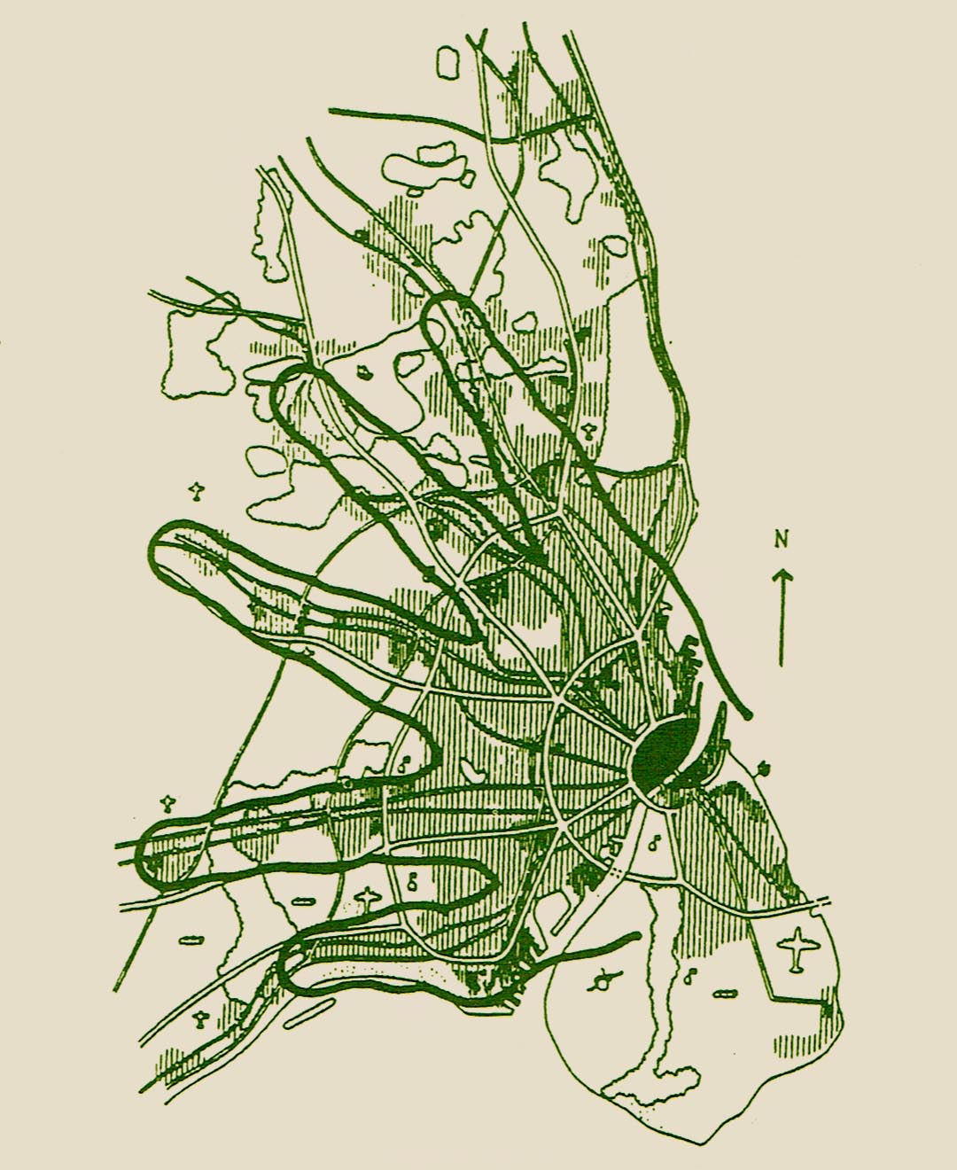
The `finger plan for Copenhagen could be taken as a historic example for introducing green spaces in existing urban fabrics
VOLUME 6 (2000)
Rebecca Williamson (University of Illinois at Urbana-Champaign): Andrea Memmos Prato della Valle
The eighteenth century Prato della Valle in Padua, Italy, one of the most surprising piazzas in Europe, conceived by Andrea Memmo, and implemented through resourceful political and economic manoeuvring, functioned simultaneously on several different levels. The solution of a hydraulic problem (flooding and stagnant water in the area of the ancient fairground) was at the same time a vehicle for a layered agenda of political, social and economic reform. Memmo proposed a hierarchical language, mingling and differentiating materials according to their durability, people according to their social status, and forms according to their use within the overall structure.
This discourse of mingling and differentiation echoes Venetian ideas about water, specifically the coexistence of fresh and salt water in the lagoon itself. Memmo named the newly restructured market in the redesigned piazza of the elliptical artificial island that was created for the Prato della Valle Fiera di Venezia in Padova, reflecting the complex relationship between the ancient university city of Padua and the sovereign city of Venice. The intent of this consideration of Memmo's ideas about design and the city is to shed light on the relationship between architectural and political designs in his work, and that of other disciples of the Venetian architectural theorist Carlo Lodoli during the final decades of the Venetian Republic, and contribute to the historical discussion of city squares and public urban spaces.
Vladimer Vardosanidze (Association of Urbanists of Georgia): Georgian culture and urbanisation
The citizen's attitude to a town or city, urban culture and the whole process of urbanisation is considered as it relates to Georgia as a Post-Soviet country at the time of its restoration to independent statehood. The historic role of the cities as cradles of culture, intellectual development, social order and religious tolerance is contrasted with the characterisation of rural life as decent and bound by ties of loyalty to the community while the big city manifests itself as the focus of evil.
The role of past migrations, folk heroes, the juxtaposition of Tbilisi between European and Asian culture, the guild system, and modern shifts in the social system and their effects on peoples attitudes to law and society are assessed to account for present nihilistic attitudes to the city as a whole, while the private space of the home is the focus of pride. The transplantation of a social system which was comprehensible in an isolated village to the conditions of city life are seen as a major causes of disfunctional attitudes to urban living.
Kutgün Eyüpgiller (Istanbul Technical University) and Saygin Eyüpgiller: The commercial and industrial past of Kastamonu, Turkey
The Turkish town of Kastamonu, in north-western Anatolia, was an important industrial and trading centre in the 18th and 19th century, and the town still retains its old street pattern and many of its old commercial buildings and market places, some still in use although many of the crafts and trades previously practised have now declined. The urban core shows the old khans or trading and warehousing centres abutting the market streets and quarters named after particular trades or occupations, with their associated mosques. The Ottoman records examined for this paper tell us much about the regulations which governed all aspects of trade, and by association the way the space within the town was organised.
Kastamonu retains much of the physical evidence of the old way of life in the core of the town, in buildings which have good potential for continuing in commercial use for small scale industry, commerce and crafts, and it is proposed that increased official support for the revival of traditional trades could be a positive force for retaining the variety of employment and ways of life in the town, as well as improving its potential for tourism, and preserving the buildings and urban fabric of the city in a manner appropriate for modern life.
Amos Rapoport (University of Wisconsin, Milwaukee): On the perception of urban landscapes
Urban design, involving relationships among components of cultural landscapes, is distinguished from other urban disciplines as involving perception. However, as used, the concept of environmental perception is too broad to be useful, and conflates perception proper, cognition and evaluation; these need to be distinguished. All urban interventions involve future states which cannot be perceived, cognised or evaluated at present. Also the problem of predicting specific futures is raised. An alternative approach is proposed, involving an emphasis on constant aspects of environment-behaviour interaction and on constant processes and mechanisms, which links the past, present and future of cities. The implications of this approach are explored and its potential utility is argued.
John D. Fairfield (Xavier University, Cincinnati, Ohio) and William Widdowson (University of Cincinnati, Cincinnati, Ohio): Of patterns and publics: planning and design as democratic process
John Dewey, America's great advocate for participatory democracy, argued that democratic participation in debate, deliberation and decision was the best means of creating an informed and intelligent citizenry. Half a century later the architect/builder/planner Christopher Alexander has recognised the same intersection of the public understood as engaged citizenry and planning process. Alexander's focus on space, planning and design is a useful complement to Dewey's abstract theories. While Dewey never gave a clear indication of how a planning society might actually look, it would probably have been close to the vision laid out in Alexander's pattern language approach. Given Alexander's consistent complaint that the results of this approach fall short of the ideal quality for which he is searching, Dewey's theory can be seen as a useful compliment to Alexander's work. It is within this intertwined set of complementaries ‒ Alexander's grounding of Dewey's abstractions and Dewy's resolution of Alexander's frustration ‒ that the necessary roles of participation, tolerance and experimentalism may be grasped, and planning and design best understood as democratic process.
Michael J. Biddulph (Cardiff University): Re-humanising critiques of suburbia
This paper presents a conceptual framework for analysing how patterns of development in suburban residential areas support or discourage activity within their public realm. The public realm in traditional patterns of suburban development is thought to offer few opportunities for anything other than necessary activities. It is argued that more variety in the types of residential setting should be provided because research suggests that people at different stages in the life cycle demand a great variety of residential settings. The need for higher densities of development also means increasing scope exists to generate a greater variety of social spaces whilst it is thought that the increasing diversity of household types should be reflected in the product of house-builders. The framework discusses how we can analyse residential settings to consider the types of activity promoted or inhibited through the pattern of layout. A number of typologies are presented illustrating the types of space that might be considered instead of a continuing emphasis on providing only private gardens and car parking spaces.
Gideon S. Golany (Pennsylvania State University): Geo-Space: the twenty-first century city
Accelerated urban expansion is exhausting most of our urban space choices, and alternative urban frontiers need to be explored. Building underground has ancient precedents in vernacular architecture and geo-space integrated deep spaces built at difõferent depths are already important for services in technologically advanced settings. Here we propose that comprehensive urban design needs to fuse the conventional supra-terranean city with a new geo-space city incorporating all the functions of a city including housing. The realisation of the geo-space city faces three main impediments: psychological obstacles (such as claustrophobia), a negative public image, and an absence of planning and building guidelines and controls geared to address this approach to building. Other major hurdles to be overcome are either technological or economic, typically involving greater initial outlay in return for long term savings. A set of principals are presented here which can be used as a starting point for a master plan for using below-ground space systematically, thoughtfully, and with design methods which exploit its potential for enhancing the quality of urban environments.
 VOLUME 7 (2001) VOLUME 7 (2001)
Gideon S. Golany (1928-1999): Urban environment: past, present and future
The late Professor Golany was dedicated to the promotion of the possibility of fundamental change in attitudes to the built environment world wide, which would have the potential for improving the nature of human existence not only
on a physical and material level, but also from a psychological and spiritual point of view. As well as teaching at Pennsylvania State University where he was Distinguished Professor of Urban Design, he also travelled and lectured extensively, particularly in China and Japan.
Here it is argued that the concept of the continuous reciprocal relationship between man, nature and heaven that is an underlying principal in Chinese and Japanese thinking manifests itself in a terrestrial orõder where social ethics govern the use of space in a way that provides for harmony, tranquillity, and a safe society. While this basic philosophy differs fundamentally from the contemporary western view of these three elements, it is argued that modern technologically advanced cities, east and west, can and should benefit from rediscovering these relationships.
Dehumanised urban society is a source of social disintegration, mental frustration and a lost sense of community, leading to personal isolation and lack of concern for public responsibility. Social conflict and discontent become the norm. What is needed is an ethic of balancing technological dominance and human mental needs whereby community and individuals can feel at home in their communities and on this globe.
The twentieth century was characterised by conflict between nations. The forthcoming twenty-first century urban environment is likely to be distinguished by new characteristics: the interaction of ethnic groups; a mix of socio-cultural groups within the urban landscape; and by accelerated urban growth and population migration. An international flavour will prevail in the medium- and large-sized city, as is already happening in major centres such as Tokyo and London. The new goals for urban designers will therefore need to focus on nurturing social sustainability. Improvements in living and working environments have the potential to offer conditions of peace and tranquillity in the urban centres, peripheries and ex-urban areas.
Jean Jinghan Chen (University of Surrey), Xiaodong Wang and David Wills (University of Greenwich): Characteristics of modern urbanisation in China
During the past 30 years, almost all developing countries have experienced rapid urban growth with the sharpest increase in urban populations being in East Asia and the Pacific Rim, as a result of industrialisation. Since economic reforms started in 1978, urbanisation in China has experienced faster growth than ever before, with unique characteristics which differ from both developed and developing countries. The changes in China are characterised by dilated urban populations, the booming of the new small to medium cities and towns, the unbalanced distribution of urban populations, residential housing problems, increases in traffic congestion and damage to the environment. Although China's urban population is growing fast the degree of urbanisation is still primary and the average growth rate of urban population during the past 50 years was slow even by the standard of a developing country. Political movements have driven urbanisation in China, in a fluctuating process which can be characterised by five phases. It remains to be seen what steps the Chinese government will take to manage urbanisation effectively.
Eamonn Canniffe (University of Sheffield): City and scene: the theatricality of public space in the Renaissance
Renaissance urbanism was the product of the overlaying of many influences of which we can readily identify three significant strands: the development of linear perspective, the desire to describe the `ideal', and the interpretation of antiquity. The matrix of perspective construction and perception found embodiment in the harmonious proportions and rhythms of the design of space in depth. With perspective it became possible to prescribe the human drama in measurable space, and by manipulation of the conventions of perspective construction to subtly heighten the effects of the space. Urban composition extended to include not only the delineation of the piazza in plan, but through perspective the control of visual, spatial and hence social relationships. Platonic geometric forms could be used to express the ideal, where the purity of the form could be understood as a manifestation of a cosmic harmony, often expressed through the metaphor of the theatre.
Theatricality as urban method appealed to the patrons of developments such as Sabbioneta, because the control exercised could be so great. The population was reduced to characters in scenarios written by the patron. In this autocratic context, as had been true since ancient times, spectacle was necessary as a component in the social contract which established the hierarchy of power. Living within a frozen urban spectacle, the inhabitants as both audience and actors could be expected to comply with stage directions, be they either theatrical or social.
Ahmad Y. Al-Zoabi (Jordan University of Science and Technology): Squares in traditional Jordanian cities
The historical development of urban spaces is considered from the point of view of the culture of traditional Jordanian cities. Special emphasis is placed upon the physical formation as well as the functions of the squares, the development of which has been directly and/or indirectly affected by natural and behavioural determinants, the key ones being the type, geographical position, topography and climate of the city, the social and cultural variables, and the economic/political factors. The main arguments and findings are based on research undertaken in three cities in Jordan: Amman, Irbid and Salt, with the aim of establishing a coherent theory in order to understand the principles underlying the layout of these towns especially the design of their squares and to provide modern urban designers with useful guidelines for incorporating the neighbourly qualities of the historical settlements into the needs of the present day in Jordan.
Nick Temple (University of Pennsylvania): From marketplace to non-place: questions of cultural atrophy
The current dominance of imagist theories of urbanism, in which the veneer and its digital reformulations are construed as the basis for establishing a new and radical construct of urban space, overlooks the essential, but largely latent, order of architectural representation that is constituted around notions of situation. Recent developments in information technology and globalisation have tended to mask the essential characteristics of both site and region, undermining the specificity of locale and its relationship to a larger horizon of topographical and cultural relationships. This has contributed to a gradual homogenisation of cities and their peripheries and at the same time to an atomisation of many aspects of society that once gave it cohesion.
The paper seeks to identify a (hermaneutic) framework for re-interpreting urban centres in which the prevailing scenographies of fashion and image can be contextualised within a historical and cultural order rather than being construed as the sole basis for authenticating reality. Looking at the corporate city, the paper argues that underlying all cities lies a continuity, embodied in public/private institutions, public space, or domestic life, that can be articulated through architecture and celebrated through festal space.
Mark David Major and Alan Penn (The Bartlett, University College London): The grid is the thing: space syntax for the Illinois Institute of Technology
The paper presents a recent space syntax study of the Illinois Institute of Technology (IIT) campus in Chicago, United States. Space syntax, an international research programme investigating the role of spatial layout as an independent variable in social systems, is concerned with such problems as: how can we measure the properties of spatial systems; what is the role of layout in movement, co-presence and higher order social phenomena; what is the nature of the relationship between social organisation and spatial layout; and, can we develop better models of spatial systems dynamic rather than static in application, if not nature which can allow us to more objectively analyse the impact design interventions will have on those social systems once they are built?
The IIT study was conducted during a recent design competition for a new student centre. The study utilised evolving representational techniques and computer software programmes originally developed in the 1980s at the Bartlett School of Architecture and Planning, University College London. The objectives of the study were to better understand the urban contextual problems of the campus and to assist Zaha M. Hadid Architects in developing a long-term design vision for the campus, which would improve its integration with its surroundings.
Teresa Stoppani (Istituto Universitario di Architettura di Venezia): Scenic chorality: Manhattan's Radio City Music Hall and the Daula Law in Venice
The notion of scenic chorality in urban space is investigated in the two paradigm islands of Manhattan and Venice, examined together as exceptional urban concentrations of density, conflicts and contamination, which escape the categorisations of both the classic and the modern. The Rockefeller Centre in Manhattan is a celebration of the culture of the Metropolis, that follows and at the same time defies the orthogonal order of the Grid. Because of its complexity and scale, the Centre contains `other' spaces, that, within its order are freed from its order and establish an inner superior order. In the interior of the scenic space (Radio City Music Hall) an artificial chorality is produced which finds no correspondence in the real city.
Venice reverses the dichotomies of Manhattan. The Daula Law prescribed that houses and palaces renounce their individual prerogatives to construct the collective body of the city. Venice asks of its buildings a chorality of intents, which displays in its urban interior that continuous collective representation which Manhattan can only rebuild by discontinuous elements inside the uterine cavity of its blocks, or fictionally in a superficially homogenous exterior/interior.
Patrizia L. Lombardi (Polytechnic of Turin, Italy): Responsibilities towards the coming generations: forming a new creed
Sustainability is still a difficult notion to define in substantive terms, but if planners and designers are to operate in such a way as to produce sustainable communities or urban development then the meaning of sustainability must be clear and agreed. An obstacle to this goal is the multi-aspectual nature of sustainability. A conceptual framework for understanding sustainability in urban planning and design is presented here. The framework is based on the holistic approach developed by the Dutch philosopher Herman Dooyeweerd, and focuses on ways of considering different levels of information, nesting all aspects of a complex problem in an ordered manner. The approach is applied to the built environment for understanding sustainability. The framework aims to help decision makers identify the sustainability aspects involved in a development or project, guiding them in the evaluation on the basis of a number of problem solving methods. It provides a significant step forward in understanding and evaluating the built environment in the context of a sustainable urban development. It also has the potential to allow evaluation of the concept of sustainability over time.
Grant Ledgerwood, Andrew Paterson and Arlene Broadhurst (University of Greenwich): Enterprise televillages: community morphological implications in regional regeneration
A new range of urban solutions, based upon teleworking and the integration of land uses, is emerging in the form of televillages. This paper reviews an application of this approach in the south of England, where it is forming a component of urban regeneration policies put in place by central and local government. In particular, consequences of televillage structures are explored for their potential impact on shaping social life and business enterprise in urban regeneration, and on the morphology of local neighbourhoods and town centres relating to changing patterns of work.
 Philip Stringer and Mehrdad Shokoohy (University of Greenwich): Revelations from mapping and morphology: urban design at Greenwich 1999-2000 Philip Stringer and Mehrdad Shokoohy (University of Greenwich): Revelations from mapping and morphology: urban design at Greenwich 1999-2000
The past and current history of our cities is embedded in the form of its fabric and often a study of the morphology paves the ground for further research. At the University of Greenwich, one approach towards urban design stresses the role of morphology, through objective and subjective mapping as well as space syntax analysis combined with people counting exercises, leading to prioritised proposals with regard to movement and integration of space. A recent student project on the Royal Docks area in the East End of London in a site featuring years of neglect contrasted with commercial development driven by financial rather than social considerations highlighted the disparate approaches indicated by objective and subjective types of analysis. The former favoured vacant space for development, while the latter indicated focusing attention on inhabited areas, and the variation in the findings served as a warning against fastening onto any particular type of analysis for curing urban ills, or proposing ways of producing fit and healthy urban environments in the first place.
The morphological approach is also applied to the University's staff research projects, particularly in the survey of the ruined 14th century town of Tughluqabad, India, where morphology was essential for revealing the probable use of the urban space. Among the questions posed was what degree of planning would have been needed at different stages to deal with the discrepancies which were bound to arise when massive fortification walls and gates were being built simultaneously with the components of the planned town, and what would life have been like for the citizens. The morphology revealed how detailed adjustments could be carried out while keeping to the masterplan, and that a feature of the residential areas was a high degree of privacy and minimal street life while public life would have been conducted in the market streets, town squares, mosques and other religious buildings. The morphological analysis of Tughluqabad is still continuing, with interesting and often surprising results.
Royal Docks, London: final synthesis of various mappings helps to identify the best case examples which may be applied to priority areas for urban improvements
 VOLUME 8 (2002) VOLUME 8 (2002)
Brian Edwards (Heriot-Watt University, Edinburgh): The Glasgow improvement scheme: politics, gender and architecture At a time when the design of urban housing and the problem of the inner cities remains near the top of the political agenda, it is worth considering the solutions adopted when city centres were last a major policy issue for politicians and administrators. In the mid-19th century the need for sanitary and social reform led to many street-based improvement schemes in Britain and Europe. The most famous, and by far the most ambitious, was Baron Haussmann's rebuilding of central Paris between 1853 and 1869 which influenced many cities, not least Glasgow, whose actions are described in this paper. Glasgow pioneered urban reform through a series of measures both regulatory and construction based. The city introduced an integrated package of measures covering housing design, street building, sewer construction, water treatment and park building which influenced many cities in Britain. A key element was the use of a modified form of tenemental courtyard housing adapted to Glasgow's climate and social conditions. This paper presents the background to the courtyard tenement or perimeter block and charts the causes for its demise towards the end of the 19th century.
John D. Fairfield (Xavier University, Cincinnati, Ohio): A populism for the city: John Dewey, Henry George and the city planning movement John Dewey's democratic philosophy is best understood in the context of the early 20th century American city. A variety of urban reform movements and initiatives represented the possibilities that inspired Dewey's democratic faith. Re-examining his democratic philosophy in light of the American city reconnects Dewey with the urban populism that helped shape his ideals and promised to translate them into concrete action. But this re-examination also reveals Dewey's failure to realise his ideals in practical engagement with the city. City planning and urban design provided an essential but neglected context for the realisation of Dewey's democratic ideals. For those still concerned about the future of the city, this re-examination also brings Dewey's democratic philosophy to bear on the practice of city planning and urban design in a way that broadens their relationship to the public. Instead of thinking of urban design and city planning in terms of results, the creation, at best, of a few public spaces that might facilitate political discussion, we should value planning and design as process. As democratic process, planning and design educate and empower the public and make the city as a whole the subject of co-operative inquiry and collective action. Alistair Barr (The University of Greenwich): SoHo, Manhattan, New York: mixed use, density and the power of the myth In 1960 SoHo was a derelict brown-field site, but now it is a vibrant New York district. This paper examines how the renewal occurred so rapidly and completely. The dramatic revival has resulted in a high density environment which provides the mix of uses usually associated with urban villages. These qualities have been bound together and sustained by the catalyst of myth making. The three terms, mixed use, density and myth are examined and their interaction over the last 200 years is plotted to demonstrate their role in providing a successful urban environment. A historical overview also shows how SoHo became a primary example of local residents overcoming city planners, and of artists taking on the role of urban pioneers. The theories of Jane Jacobs and Kevin Lynch are applied in the analysis of the components of this fast and vigorous urban renewal which can offer many lessons for current brown-field sites. The changing fortunes of the area, from a freed-slaves' settlement in the mid-17th century, to a gracious semi-rural residential area, and the impact of the 1811 grid of avenues and streets with the massive expansion of New York as commercial capital of the New World is traced. In 30 years Broadway and the nearby blocks south of Houston and north of Canal Street had become a thriving centre for industry, commerce, entertainment, night-life and famous shops, but this centre moved northward, leaving a legacy of neglect. It became an example of how a dense urban area without mixed uses can become derelict and forgotten. The historical overview also shows how SoHo recently became a primary example of local residents overcoming city planners, and of artists taking on the role of urban pioneers. The theories of Jane Jacobs and Kevin Lynch are applied in the analysis of the components of this fast and vigorous urban renewal which can offer many lessons for current brown-field sites. Benz Kotzen (The University of Greenwich): Changing attitudes: the creation of urban shade in the Negev Desert In hot desert areas man cannot live without shade and throughout history people have avoided the harshest aspects of climatic conditions through the control of micro-climate. Today, in many hot and arid areas, micro-climatic is moderated largely indoors as well as in motor vehicles through `non-sustainable' air conditioning units. This reliance on technology negates the tried and tested historical methods of tempering micro-climate within development. One of the main issues regarding micro-climatic intervention is the moderation of solar radiation through the creation of shade. In urban areas, shade is a key component for the use of outdoor space as well for tempering the energy uptake in buildings of radiation energy from the sun. Historical developments in hot dry areas in the Middle East and the Mediterranean illustrate the concern of their designers, planners and citizens with shade and micro-climate adaptation through the creation of narrow streets, and appropriate elevations for buildings and their alignment within the urban fabric. The Negev desert, in southern Israel, has a long history of development from ancient times until the present. Changes in urban design came about mainly recently with the use of motorised transport and the establishment of western European and North American ideas and ideals. The arrangement and ordering as well as the heights of buildings largely ignore the desert environment and the need to create shade. Whereas in the past the close integration of built form would create an oasis experience and keep the desert at bay, now the mind-set is to create internal oases through air conditioning. External landscape oases with large areas of grass, shrubs and exotic trees are created using cheap, subsidised water. This unsustainable trend is especially noteworthy in this region as water is exceptionally scarce and water is an issue of conflict amongst countries in the area. Using vast amounts of water for landscape purposes is wasteful as it is better used in industry, for domestic purposes and in agriculture. An assessment of past and present development in the Negev region indicates a shift away from close knit urban forms. However, some developments do illustrate a considered micro-climatic approach to the design and layout of the infrastructure and built forms. The investigation of these developments shows that micro-climate is a concern but that there still appears to be an over-emphasis on private comfort as opposed to overall micro-climate temperance. The move away from the use of compact and integrated structures in urban planning in the Negev means that the shade which might be created by built form now has to be provided by external shade structures and water consuming trees. Laurence Pattacini: Better places to live: learning from the French experience This paper considers alternative development processes and practice which may improve the quality of new residential developments in Britain according to the latest thinking in urban design with respect to issues such as identity, vitality, permeability, sustainability and mixed-use. The aim is not to set out exhaustive rules but to broaden the range of urban design methodologies which might be used to achieve better places to live. This is achieved by examining development control practice and new residential areas in different contexts around Paris. The more prescriptive French planning system and political commitment to urban design appears to have a greater capacity for facilitating the creation of high quality living environments. The findings derived from the case studies could help formulate recommendations on urban design and development control. This includes the decentralisation of political power and the formation of partnerships between the private and public sector for a better fulfilment of long-term public interest. Furthermore, the case studies demonstrate the importance of the characteristics of the existing environment as a source of inspiration for new developments, and the necessity of a well-defined design rationale for achieving high quality urban spaces. Mohammad Abdullah Eben Saleh (King Saud University, Riyadh, Saudi Arabia): Imagery and form: Arriyadh city core City cores worldwide suffer from urban decay and deterioration due to changes in economic, technological and managerial means and outlooks. The capital of Saudi Arabia, Arriyadh (Riyadh), developed from a mediaeval Islamic town to a modern metropolis in a matter of decades, and the forces behind the initiation, transformation, evolution and implementation of its urban imagery and form are identified and highlighted. The reflection of religious and cultural traditions and sound environmental planning in the recent redevelopment of Arriyadh city core aimed to enhance its urban imagery and form through the power of physical elements and their potential for encouraging social interaction. To prevent the decline of the centre of the capital city, the Arriyadh Development Authority (ADA), a top-down planning authority headed by the governor of Arriyadh, planned and executed two major projects between 1975 and 1999, the Qasr al-Hokm District (QAHD) around the Royal Palace and the King Abdulaziz Historic Center (KAHC) with its mosque, museum, auditorium, libraries and archival and research centre as well as plazas and parks for the enjoyment of the public. The approach to combining restored and new buildings incorporating the traditional features of the local vernacular Nedji architecture with entirely modern structures and urban infrastructure is discussed, along with the functional and symbolic relationship between the ruling system and the population. The Qasr al-Hokm District exemplifies the traditional relationship between the main congregational mosque and the ruler's palace, while al-Emarah (Government House) represents the ruling authority; the town hall the legislative authority; and the police headquarters the executive authority. The open squares can be seen as the heart or domain of the population. The district is also occupied by commercial and private administrative buildings, covered wholesale and retail markets (suq), commercial centres and office buildings. John Wakefield (Leeds Metropolitan University): 2000 2020 Housing issues: Malaysia During the 1997/8 period Malaysia was hit by an economic crisis which saw a serious devaluation of the Malaysian Ringgit, a stock market crash, and the construction industry in crisis with over supply of housing and stalled projects. There were recriminations and scapegoats found. The aftermath of this difficult period has been a reflective, yet positive phase, with a number of housing issues being rethought, reviewed and reflected upon by government, developers, architects, planners and users. Current issues such as: quality and value, precedent, ecology, sustainability, legislation, construction standards and profitability need to be considered in the context of the design of new townships, and the shift from traditional housing forms to condominiums and commercial developments. Considering Malaysia's ongoing experience as a developing country with a government intending to achieve technological advancement may point out some essential components and issues pertaining to the future of urban developments. Victor Margolin (University of Illinois, Chicago): Urban artifacts: a theory of types Histories and theories of urban design tend to focus on buildings, parks and plazas, while little if any attention is paid to the vast array of objects such as kiosks, benches, bus stops, recycling bins and public sculptures that crowd the cityscape. Instead, such objects, including transport vehicles for goods and people remain invisible as a part of urban studies and no typology exists that can be used to classify them. Rather than adopt a taxonomic method to group individual objects according to particular characteristics of form or use, one can consider these artifacts as components of interconnected systems that form the urban fabric. The systems derive from categories of activities and processes that occur in the city the circulation of goods, waste and people; the distribution of information; recreation; communication; the exchange of goods and services; and the production of culture, among others. The paper describes these categories and suggests the kind of objects that belong in each. The categories are related through the concept of the overlay whereby each system of objects can be overlaid on the others in order to build up a dense network of artifacts in urban space.  Mehrdad Shokoohy (The University of Greenwich): European Connections, Gravesend and Malmo: urban design at Greenwich 2000-2001 Mehrdad Shokoohy (The University of Greenwich): European Connections, Gravesend and Malmo: urban design at Greenwich 2000-2001
Urban design still does not benefit from a universally accepted definition, and approaches to teaching the subject vary greatly from one institution to another. One of the aims of Urban Design Studies is to provide a platform for teachers and institutions to set out their particular approach. The students' projects in the Urban Design Atelier at Greenwich in the past year focused on the use of mapping in the development of the design process. Two sites were chosen: one in England at Gravesend, an old industrial port at the mouth of the Thames in Kent, and another in Sweden at Malmo, once a sleepy fishing harbour and now an industrial town. Although the history which has shaped the urban fabrics of these two towns has little in common, both towns face serious challenges to adapt to modern life and a use of space radically different from that of the past, particularly because of new infrastructure in the European transport networks.
Gravesend, a proposed mixed use scheme for a brownfield site The Gravesend project focused on the potential of the town for growth provided by the proposed introduction of a high-speed rail link to London and another to the new Ebbsfleet station on the Channel rail link to Europe. Mapping exercises indicated that the former segregation into industrial, residential, commercial and retail uses had not only become inappropriate because of the closure of the docks and associated industries, but had also killed off the connections between different parts of the town. A series of green fingers or tentacles were envisaged which could reach up into the town from the river whilst simultaneously `urban' tentacles could stretch down to the waterfront, to encourage development towards the river and renew the town's orientation to the Thames. In Sweden the students' project was conducted in conjunction with the University of Stuttgart, to conõsider the impact of the recently constructed Oresund Bridge connecting the trunk road from Denmark to Sweden where it passes through Malmo. This small historic town had its old urban centre close to the fishing harbour at the north-west, but its proximity to Europe has already attracted large and small-scale industries to the south of the town closer to the bridge. Three major strategies were proposed by the students for implementation in stages over the next two decades: to join the city fabric; to inter-link the green areas; and to introduce a light-railway network to integrate the smaller local centres with the old traditional urban core and the new proposed one. Firm boundaries were proposed to encourage high density mixed use and prevent urban sprawl in the future. Independent research by colleagues at Greenwich includes the papers by Alistair Barr and Benz Kotzen published in this volume, and the editor's long term projects are continuing on the survey of Tughluqõabad, a fourteenth century capital of the Delhi sultanate, and on the town of Kirtipur in the Kathmandu Valley of Nepal. Follow up studies of the continuous and rapid change in land-use in Kirtipur, a revealing phenomenon of third-world towns located near large centres of population have been carried out, and another programme is concentrating on cataloguing some one hundred street shrines of the town: landmarks or nodes, which characterise the Hindu-Buddhist towns of the Kathmandu Valley. These shrines contain religious images, many of which are part of the townspeople's everyday worship and are of considerable cultural, historic and artistic value.
|